![]()
|
|
|
The Nellis UFO Video: |
"WHERE'S IT COME FROM?"
A STUDY OF THE 1994 NELLIS UFO FOOTAGE
PART ONE
by Martin J. Powell
In February 1995 the American TV show 'Hard Copy' broadcast a videotape showing an unidentified object flying over a North American military test range. Further footage was shown the following December on the 'Sightings' TV show.ref 1 The videotape had apparently been filmed by a high-tech Air Force surveillance camera at an undisclosed location within the Nellis Air Force Base Bombing and Gunnery Range Complex, Nevada (often referred to simply as the Nellis Test Range).
The videotape is said to have been smuggled out by contractor personnel who had operated tracking stations on the Nellis range. Copies of the videotape were sold to Paramount Studios (producers of 'Hard Copy' and 'Sightings') by a former Air Force employee who worked on the range, although apparently he had not witnessed the object himself.2
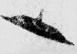
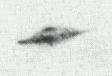
Two sections of videotape showing the UFO have come to light. The first section was filmed from a location known as S-30, according to the camera's data display. This shows the object initially as an indistinct 'blob' flying in front of a distant mountain range, before it turns and heads towards the camera location. The camera operator struggles to keep the object within shot as it approaches, and it soon becomes clear that it cannot be identified. It looks similar to a blimp, but with four light-coloured 'lobes' and a dark region at the front (Figure 1, 9 KB). As it nears, it turns to face the tracking station for several seconds, as if performing some kind of surveillance, before it turns away and departs. The footage is of special importance because the voices of the camera operators at the tracking station can be heard on the noisy soundtrack. Their bewilderment at the unexpected appearance of the UFO is clearly audible. "What the hell is it?" one of them exclaims; "Where's it come from?" asks another (listen to sound clips and see a transcript of the S-30 footage here).
 Figure
1 The
Nellis UFO, shown in two different views from the S-30 footage (click
for full-size image, 9 KB).
Figure
1 The
Nellis UFO, shown in two different views from the S-30 footage (click
for full-size image, 9 KB).
The second section of footage was filmed some 40 minutes later, from camera location S-13. This shows the UFO as a small dot on the horizon, moving away from the tracking camera. Although it has less visual impact, the soundtrack to this section is important because the controllers are heard to simulate a missile launch on the object. It remains visible, however, eventually disappearing into the realm of mystery and speculation that surrounds the Nellis Range.
The footage has been studied by both UFO researchers & aviation experts alike, but to date no-one has been able to provide an explanation as to what the object is, how it is propelled or how it is able to perform the manoeuvres it is seen to do.
Having taken place inside the range, the most likely explanation for the UFO would seem to be that it was a top secret 'black project' which for some reason was allowed to fly in full view of the surveillance cameras. However, according to one anonymous source in the 'Sightings' programme, the camera operators are not exposed to such tests of new technologies, the camera lenses being capped and the equipment turned off during such occasions.3
In the first part of this study, I will examine the likely nature of the equipment used to film the object, and also attempt to find the location of site S-30, using evidence gleaned from the footage. I will begin with a brief overview of operations at the Nellis Range.
The Nellis Range
The Complex is situated some 40 miles North-west of Las Vegas, and comprises around 4,700 square miles of largely desert landscape. It includes the highly restricted areas known as the Nevada Test Site, Tonopah Test Range and the famed Area 51 (Groom Lake). The Range undertakes numerous activities, among which are the training of Air Force pilots in combat exercises and the testing of new aircraft, weapons and other equipment. In the 1950s and '60s the area was used extensively for testing nuclear weapons, which continues today on underground low yield atomic devices. The range was used for the secret development and test flights of, among others, the U-2, SR-71 and Stealth aircraft. The remote location of the range, together with its highly restricted access, ensures that experiments on all types of equipment can be carried out in relative safety and out of the reach of the curious public gaze.
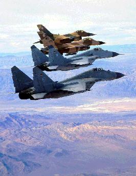 German
MiG-29s fly in formation with American F-16 Falcons over the Nellis
Range during a Red Flag exercise (click for full-size image,
19 KB) (Official US Air Force
Photo)
German
MiG-29s fly in formation with American F-16 Falcons over the Nellis
Range during a Red Flag exercise (click for full-size image,
19 KB) (Official US Air Force
Photo)
The precise nature of the instrument that recorded the Nellis footage is not clear. The general consensus of opinion amongst researchers is that it was filmed using a tracking camera which was attached to a targeting radar. These radars are used at the Nellis Range as mock enemy targets which air force pilots seek to locate and 'destroy' whilst attempting to remain out of the radar's detection. The 'threat radars', as they are known, operate at wavelengths which they would be expected to use in genuine combat situations, and they are often Soviet made.4 Air Force pilots from the US and other NATO countries frequently take part in 'Flag Exercises' at the Range in which their tactical skills are tested to the full, involving both dogfights and live bombing runs.5 The aircraft are filmed during the exercises so that the pilots can review the footage at a later stage and assess their performance.
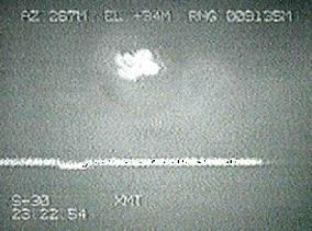
Tracking Camera Display Features
The S-30 camera display appears similar to a monochrome CCTV and has several overlaid data items (Figure 2, 14 KB). Across the top of the screen are displays for azimuth (AZ), elevation (EL) and range-to-target (RNG). The letters 'A' or 'M' variously appear next to each of the values. On the lower part of the screen are the site designator (S-30 or S-13) and the time in UTC (Universal Co-ordinated Time), which is equivalent to GMT and is used as standard for all Air Force operations.6
Nearby are the letters XMT, which may stand for 'transmit' mode. A wavy line appears below the middle of the screen, whose appearance varies considerably throughout both sets of footage. This is probably the radar return or 'signature', which is used to help identify the nature of the target. The data appearing on the display are typical of those that would be required to fix a target's position in space and time, and they would be displayed at all tracking stations in one form or another.7 In practice, the data from several such tracking devices would be fed to a central command post, allowing the position of the target to be determined to within an accuracy of about 1 metre.8
 Figure
2 The
tracking camera display as it appears in the S-30 footage (click
for full-size image, 14 KB). The S-13
display is similar, but with the additional letters 'CG' and 'LAU'
at the lower part of the screen.
Figure
2 The
tracking camera display as it appears in the S-30 footage (click
for full-size image, 14 KB). The S-13
display is similar, but with the additional letters 'CG' and 'LAU'
at the lower part of the screen.
The tracking cameras are often remotely controlled, however evidence from the Nellis UFO footage suggests it was a manned station. At one point in the S-30 footage (between 23:21:08 and 23:21:13 UTC) the camera is put into an 'auto-guide' mode, when it is left to track the object automatically. At this point the letter 'A' appears next to the azimuth, elevation and range displays. The camera fails to lock on to the target, however, and the camera operator takes over manual control (at which point the letter 'A' is replaced by an 'M'). Throughout most of the S-30 footage the camera is under manual control, shown by the data suffix 'M'. In the S-13 footage, when the object is moving away at a considerable distance, the camera tracks the object automatically. A significant bump is seen in the radar return, presumably indicating a clearly defined target. This is unlike the radar return in the S-30 clip, which is highly erratic at the beginning and suddenly 'flat lines' part way through. When the behaviour of the radar return is studied alongside the distances shown in the range display, the two items appear to be closely related.
|
|
Determination of Filming Location S-30
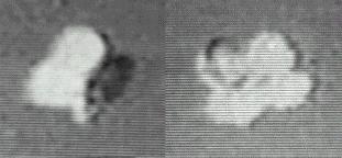
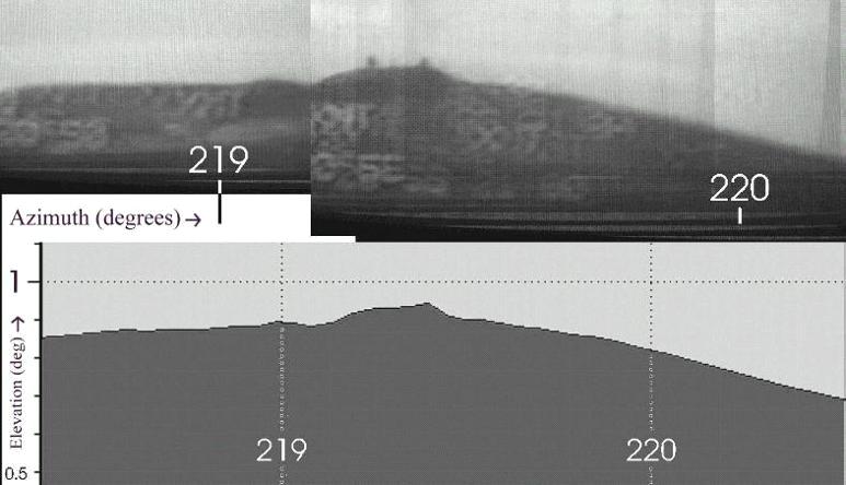
The only clue as to the location of S-30 appears at the very start of the footage, when a mountain is seen in the distance, behind the UFO. The mountain is visible for just under half a minute, after which the camera pitches upwards to follow the UFO and from this point onwards, all sight of the landscape is lost. The mountain does, however, have a distinct profile, and two radar domes are situated on its flat summit. I took a series of still shots from the video and assembled them into a montage (Figure 3 upper, 40 KB). The fact that the mountain appears relatively small in the footage and only measures a couple of degrees across suggests that it is a considerable distance away from the filming site.
Until now, the mountain has not been positively identified, although previous researchers have considered various possible candidates. A 'Groom Lake Desert Rat' newsletter correspondent suggested that it could either be Black Mountain, Quartz Mountain or Tolicha Peak, located on the western side of the range in a restricted area known as the Tolicha Peak Electronic Combat Range. The presence of the radar domes, says the newsletter, should make the mountain "easily identifiable".9 Regarding sites S-30 and S-13, David Rudiak points to the existence of an Area 30 within the Nevada Test Site, and also an Area 13 near Groom Lake.10 Susan Michaels, in her account of the Nellis sighting, says simply that the object was filmed at the 'North-western corner of the range'. Television items have claimed that the footage was filmed "inside Area 51".
I considered the best starting point would be to examine the mountains suggested by the Desert Rat newsletter correspondent. Contour maps of the Pahute Mesa and Cactus Flat regions, which included these mountains, were downloaded from the US Geological Survey website.11 Closer scale maps were obtained of the Black Mountain, Quartz Mountain and Tolicha Peak areas. Careful inspection of the contour maps indicated that Black Mountain was the most likely of the three possibilities. The 1:100,000 scale maps were printed out and assembled, and the azimuth line to the mountain summit (derived from the footage as approximately 219�.4) was drawn on the map in a reciprocal direction from the summit. The correction for convergence (i.e. the difference of Grid North from True North) was 18 minutes of arc and was considered too small to significantly affect the azimuth line plot on the map.
 Figure
3 (Upper) Black Mountain, Nevada, as it appears from tracking
station S-30, in the early part of the Nellis UFO footage (click
for full-size image, 40 KB). This image is a montage
of numerous screen shots taken over a period of about half a minute. (Lower)
The author's computer-generated profile of Black Mountain, as it would
appear from a location 21.4 miles to the North-east of the summit. The radar
domes have been omitted from the profile. The lower image was composed using USGS
map data.
Figure
3 (Upper) Black Mountain, Nevada, as it appears from tracking
station S-30, in the early part of the Nellis UFO footage (click
for full-size image, 40 KB). This image is a montage
of numerous screen shots taken over a period of about half a minute. (Lower)
The author's computer-generated profile of Black Mountain, as it would
appear from a location 21.4 miles to the North-east of the summit. The radar
domes have been omitted from the profile. The lower image was composed using USGS
map data.
In order for the distance of the mountain to be determined, an estimate was needed for the elevation angle of its summit, as seen from the camera location. Unfortunately there are no anchor points to fix the location of the horizon line (i.e. where the elevation is zero degrees). At the start of the footage the elevation reads 1�, and by the time the object is 2� high the landscape is out of shot. Background cloud layers were too indistinct to be used as anchor points. The width of 1� in azimuth was, however, determined as the object moved across the mountain backdrop; the points at which the azimuth changes to 219� and 220� are marked on the montage in Figure 3. Using this measure as a reference, and then extrapolating the object's position at the 2� high point, the elevation of the mountain top was estimated to be around 0�.92. I then wrote a computer program (in the BASIC language) which calculated the theoretical distance of the mountain (summit height 7234ft/2205m amsl) on the basis of a 0�.92 summit elevation and using a range of possible tracking station ground heights. The ground heights were based on the successive contour line values leading to the mountain along the 219�.4 azimuth. The calculation of the summit elevation took into account the curvature of the earth, which can have a significant effect on horizon elevations when measured over very long distances. The initial program output suggested a filming location of around 21.4 statute miles from the mountain, and a tracking station ground height of around 1560m amsl.
A mountain profile was prepared, on the basis of these initial values, in the following manner. Azimuth lines were drawn at 0�.05 intervals, from the suspected tracking station location 21.4 miles from the mountain summit. The azimuth range of the profile plot covered 2�.16, matching that of the printed montage. The 1:24,000 scale map of Black Mountain was used to obtain accurate distances and contour values (plotted at 40ft intervals). Because of the large distance involved, both the 1:24,000 and 1:100,000 scale maps were required to determine precise distance values, which involved a small correction in order to tie in the different map scales. A second computer program calculated the angular elevation of each successive contour line away from the station point, and determined the highest value for each azimuth line. The resulting azimuth and horizon elevations were then plotted to produce a profile of the mountain as it would appear from the selected viewpoint 21.4 miles away (Figure 3 lower). The profile is essentially identical to that seen in the footage, proving conclusively that the mountain is indeed Black Mountain, viewed from the North-east. This places the filming location deep within the Nellis Range, which undoubtedly strengthens the authenticity of the footage.
 Radar
domes on Black Mountain, Nevada (click for full-size
image, 9 KB). These are the same domes
that appear at the start of the S-30 footage (Official US Air
Force Photo)
Radar
domes on Black Mountain, Nevada (click for full-size
image, 9 KB). These are the same domes
that appear at the start of the S-30 footage (Official US Air
Force Photo)
The two radar domes on Black Mountain, so clearly visible in the footage, are not marked on the 1988 map. An access road ascends the mountain on its North-eastern side, and were it not for the poor contrast, should be discernible in the footage. The radar domes are apparently used as targets for fighter pilots when on Flag exercises.
Having positively identified the mountain, the next step was to refine the location of site S-30. Careful measurements of the montage printout suggested a likely mountain summit elevation of between 0�.73 and 0�.95. In order to determine the most accurate location of the site, the values of each contour were programmed into a computer program along with their associated distances from the mountain summit, taken from the 1:100,000 scale map. The program compared the actual contour values with those that would be required in order to obtain a summit elevation between 0�.73 and 0�.95. The program used a tracking station ground height range of between 1400 and 1950 metres amsl, with a ground height tolerance of �1 metre and 0�.01 increments of horizon elevation. These were the smallest tolerances that could be expected from the available maps. The program output suggested a station distance of between 19.1 and 23.3 statute miles from Black Mountain, with station ground heights of 1540 and 1616 metres amsl respectively. No station heights were found to match the mountain summit elevation above 1�.1, which in any case had been considered too high for the mountain top. Because of the lower limit set for the summit elevation (0�.73) no station heights were calculated beyond a distance of 23.3 statute miles from the mountain.
Consequently it would appear that the most likely filming location of the S-30 footage (and by implication, the location of S-30 itself) lies at a distance of 21.2 � 2.1 statute miles North-east of Black Mountain, i.e. within a 4.2 mile NE-SW line centred on co-ordinates N 37� 31'.26, W 116� 23'.99. This is marked as a red line on the map in Figure 4 (101 KB).
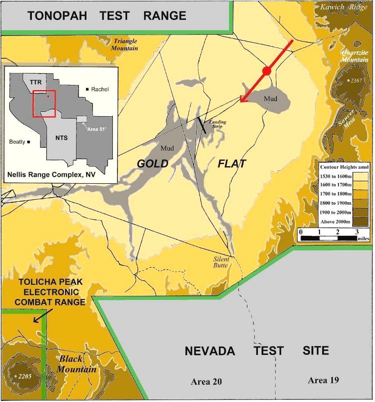 Figure
4 The location of site
S-30 most likely lies somewhere along the red line marked on this area map. Streams have been omitted for clarity. Based on USGS maps (click for full-size image, 101 KB).
Figure
4 The location of site
S-30 most likely lies somewhere along the red line marked on this area map. Streams have been omitted for clarity. Based on USGS maps (click for full-size image, 101 KB).
The filming location lies at the North-eastern corner of Gold Flat, on the boundary between Ranges 74 and 75E, which are used for bombing and gunnery training on 'high value high threat targets'. Examination of the 1988 map of this region reveals a relatively featureless landscape, with gently rising land towards the North-east (i.e. away from Black Mountain) and a couple of minor access roads running predominantly in a NW-SE direction. To the South is a large mud basin whilst to the South-east is the appropriately named Saucer Mesa. Quartzite Mountain dominates the skyline to the East of the site and Kawich Ridge continues along the skyline to the North-east. The nearest man-made features marked on the map (apart from the roads) are a mile-long landing strip 4 miles to the South-west and a pair of towers 4 miles to the North-west, just inside the boundary of the Tonopah Test Range (TTR). In terms of airspace, the site lies within the restricted area referred to on aeronautical charts as R-4807A, between the Nevada Test Site (to the South) and the TTR (to the North-west).12 Ironically, this section of airspace was opened up to civilian air traffic on weekends from July 1995, whenever Flag exercises were not in operation.13
|
|
Date & Time of Encounter
According to Michaels, the videotapes date from late September 1994.14 The date of the encounter can in fact be estimated from the S-30 footage because the object is seen to fly into the Sun (or close to it) at 23:22 UTC. Knowing the filming location and the approximate co-ordinates of the Sun at this time, a range of possible dates can be determined for the encounter. I wrote a computer program in order to calculate the dates with high accuracy. Using a solar azimuth of 233� (estimated from the videotape) and taking the year as 1994, two narrow date bands are found. These are in mid February and late November / early December. The sun's elevation would have been around 18� and 9� respectively (the elevation of the UFO at the time was 16�). Contrary to the 'Sightings' claim, the sun does not attain the position shown in the footage at 23:22 UTC on any date in September. Using Michael's autumnal date only as a guide, it seems that the Nellis footage was most likely shot in late November 1994.15
If this date is correct, the encounter would have taken place about an hour before local sunset, which occurred at 1628 PST.16 The S-13 footage would have been taken about 20 minutes before sunset.
The proximity to sunset is interesting because, according to one cinetheodolite operator at the TTR, this is considered to be one of the two "prime times" for the optical tracking of test subjects (the other being half an hour after sunrise).17 Camera trackers can easily lose their targets in the strong heat shimmers of the daytime. By timetabling the tests for the dawn and dusk periods, the shimmers, (or 'worms', as they are called) are kept to a minimum.
Summary
In all probability, S-30 and S-13 are not 'areas' in the strictest sense, but more likely the locations of the individual tracking radars (the 'S' presumably standing for 'Site' or 'Station'). Being less than three miles outside the TTR boundary, the relationship of S-30 to the TTR seems in little doubt. Several access roads are shown on the 1988 map leading out of the TTR to the approximate area of S-30 (see Figure 4).
Clues as to the nature of the operations and equipment used to film the footage might come from a variety of anonymous sources. Michaels gives accounts by two range operators who were prepared to speak on the 'Sightings' TV program. One described himself as a "video tracker" and said that he was present in the 'control room' on the day of the sighting. He confirmed that there are hundreds of cameras on the range and that aircraft tracking and identification is done there on a daily basis. No-one who was present - not even the 'range control' - were able to identify the object.
Area 51 publicist Glenn Campbell cites the case of a former female radar operator at the Nellis range who operated from a closed threat-radar trailer, which is evidently able to manoeuvre around the range and present threats to aircraft from unpredictable locations.18 Her description of the equipment and operations at the range seem appropriate to those that we see in the Nellis footage.
The location of S-30, on the open bombing range between two highly secure test sites, seems appropriate for such a mobile trailer, presumably operating out of the TTR. One might even suggest that 'T-1 Control', referred to in the S-13 commentary, might refer to the 'Tonopah' range control.
One commentator has claimed that the voices of the radar operators sounded "really calm" during the encounter, presumably because encounters of this kind take place frequently on the range.19 Whilst I do not agree that the controllers sound calm, it certainly seems peculiar that none of the personnel on the soundtrack make any reference even to the possibility that the object could have been an experimental device operating out of one of the neighbouring test sites. Nonetheless there is little doubt that, having been filmed by an Air Force camera inside a highly secure test range, the Nellis footage must be one of the most important pieces of UFO material to emerge in recent years.
|
|
1. The complete S-30 clip is included in the video compilation 'UFOs: The Footage Archives (Part 3)' by Michael Hesemann and Nadia Zahradnikova, 2000 Film Productions, D�sseldorf (1998). The date assigned to the clip (30.5.95) is, however, incorrect.
On the Internet, the S-30 footage can be seen at the following sites:-
(a) YouTube (general search query)
(b) An excerpt from the 'Hard Copy' TV programme which first featured the Nellis UFO (broadcast 17th February 1995) can be seen on YouTube. It includes comments by military technology expert Chuck DeCaro and brief clips of the S-13 footage.
(c) Excerpts from two 1995 'Sightings' TV programmes featuring the UFO video can also be seen at YouTube. The first programme includes comments by aerospace journalist Bill Sweetman, independent analyses of the video by Chuck DeCaro and video processing expert Chip Pedersen, and brief clips of the S-13 footage. The follow-up episode features an analysis by an anonymous Defense Department subcontractor, in which he compares the UFO with a similar object filmed over Mexico City in 1991.
2. 'Nellis "UFO" on Hard Copy', Area 51 Research Center website run by Glenn Campbell. This is a very large website concentrated on UFOs and related topics, with an extensive archive of information, but the site is no longer maintained.
3. Susan Michaels, 'Invader on the Range', in Sightings: UFOs, Simon & Schuster, New York (1997), pp. 119-130. According to Michaels, the US Air Force would neither confirm nor deny the existence of sites S-30 and S-13. The US government has 'no comment' to make on the footage.
4. Little A'Le'Inn website (Dreamland Resort).
5. For a detailed assessment of Flag Exercises and other details of the Nellis Range see the Dreamland Resort website (ref. 4). Nellis Air Force Base has its own website here.
6. The time displayed in the S-30 footage starts at 23:21 UTC, which equates to 15:21 local time at the Nellis Range, i.e. in the afternoon. This dismisses an earlier claim that the object was filmed at night by an infra-red camera.
7. The camera display is consistent with that of a surveying instrument, such as a cinetheodolite. Aviation historian Curtis Peebles considers this to be an unusual instrument for tracking fast-moving aircraft on military exercises, where the positional data would change very rapidly. Peebles thinks that the display seen in the footage may be from a 'big board', such as might be found in a central control room, showing readings from different tracking systems. The precise nature of the instrument used to film the footage must therefore remain in some doubt. I am grateful to Curtis Peebles for providing me with background information regarding tracking station data displays.
8. 'Cameras, Radar Keep Eyes on Test' in Sandia National Laboratories "Lab News", July 26 1991, originally reproduced on Tom Mahood's website. Sandia Labs operate the TTR facility on behalf of the Department of Energy. They primarily perform development testing on DoE funded weapons programs. This edition of newsletter provides details about the link-up of tracking stations, radars and the Operations Control Center within the TTR.
9. Ref. 2.
10. 'The Nellis Range UFO Video' by David Rudiak (1997). Rudiak's updated article can be seen at his Roswell Proof website.
11. United States Geological Survey 1:100,000 scale maps of Cactus Flat (1988) and Pahute Mesa (1979), and USGS 1:24,000 scale maps of Black Mountain (1988), Tolicha Peak (1986) and Quartz Mountain (1980).
12. An aeronautical map of the Nellis Range is shown on the Dreamland Resort website.
13. One such overflight was made by Area 51 researcher Tom Mahood in March 1996. His flight took him directly over the identified S-30 region. Mahood noted many bombed out areas in the vicinity, and also giant 'bulls-eyes' which are used as targets for air-dropped weapons. See 'A Grand Aerial Circumnavigation of Area 51' here. The Department of Transportation docket detailing the airspace change is also reproduced on Mahood's website. See 'Airspace change to R-4807A and R-4808N' here.
14. Ref. 3, pg. 120. 'Real TV' dated the video to 1993, whilst a NICAP investigator believed the encounter took place on 30.9.1991.
15. This date is in agreement with an independent assessment by David Rudiak (personal communication).
16. US Naval Observatory website.
17. Ref. 8.
18. Glenn Campbell, 'A Report on what the "UFO Mechanic" had to say on his own Las Vegas Call-In Radio Show', here. Close-up photographs of a threat-radar trailer (taken on the road to the TTR and to Area 51) can be seen at Gary Sellani's Lazy G Ranch website.
19. Terry Colvin, 'Beyond The Illusion' File Archive (August 1998). See also The Journal of The Inquiring Skeptics of Upper New York, Volume 1, Issue 3, 'The UFO Skeptic'.
|
The Nellis UFO Video: |
 Trindade
Island UFO Photos (1958)
Trindade
Island UFO Photos (1958)
Copyright Martin J Powell 2002