Southern Dartmoor
Some Prehistoric Sites in 3-D Stereo
by Martin J. Powell
How to See the Pictures Stereoscopically
The following photographs were taken in the Southern region of Dartmoor, Devon (England) in April of 2003.
Users viewing the mobile-optimised version of this web page will see a thumbnail of the 3D picture. Whilst this can be viewed successfully in 3D, an optimal-sized, higher resolution image can be seen by clicking on the thumbnail (all of the full-size 3-D images on this page are less than 35 KB in size).
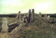
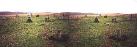
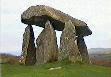
Cuckoo Ball
Neolithic Burial Chamber
Ordnance Survey Grid Ref: SX 660 580
O.S. Map (Streetmap)
Original Photo (Non-Stereo) (144 KB)
Located on the South-east facing slope of Butterdon Hill, near the town of Bittaford.
The chamber is ruinous, with two upright portal stones and a jumble of smaller orthostats. It occupies the Northern end of a low, long mound some 23 metres long by 12 metres wide (75 ft by 39 ft). The chamber appears to have been orientated towards the East. The monument most likely dates from the Neolithic period.
The photo was taken looking Eastwards towards Ugborough Beacon, 0.5 mile (0.8 km) distant.
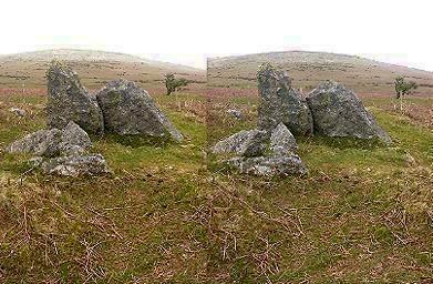
Corringdon Ball
Bronze Age Stone Row Complex
Ordnance Survey Grid Ref: SX 667 612
O.S. Map (Streetmap)
Original Photo (Non-Stereo) (132 KB)
A mini-complex of stone rows can be found in a secluded spot close to East Glaze Brook, two miles (3.2 km) North-west of the town of South Brent.
There are seven stone rows in total, and possibly an incomplete eighth, all of them comprising small stones. There are two triple rows, fan-shaped in plan and orientated NE - SW. One group is 79 metres (260 ft) long and the other 67 metres (220 ft). Both groups diverge as they lead towards a cairn-circle, of which only a single quadrant of upright stones survives.
The photograph shows the seperate, single row at the North-west, the most identifiable of the group. It extends some 155 metres (508 ft), roughly parallel to the others, towards a round barrow. The photograph was taken looking South-west towards Butterdon Hill.
Visible on the skyline a short distance to the North-east of the rows is the Corringdon Ball Gate Neolithic chambered long barrow (SX 669 613). The barrow measures 40 metres long by 20 metres wide (130 ft by 65 ft) and has a collapsed burial chamber at its South-eastern end.
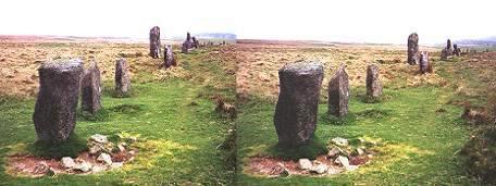
Ringmoor
Bronze Age Stone Row & Cairn-Circle
Ordnance Survey Grid Ref: SX 564 662
O.S. Map (Streetmap)
Original Photo (Non-Stereo) (127 KB)

Situated on Ringmoor Down to the North-east of the village of Brisworthy, this row is an impressive 530 metres (1740 ft) in length. It comprises small to medium-sized stones and has a tall terminal stone at its Northern end. It is now mainly a single row of stones, although it is double in parts, and may originally have been entirely double. The row is orientated NNE - SSW and at the Southern end is a cairn-circle 12.5 metres (41 ft) in diameter (see below). The circle was restored in 1909, at which time five extra stones were added to it from the surrounding moorland.
The photograph was taken looking Northwards, i.e. facing away from the stone circle.
The Ringmoor cairn-circle, seen from the North:
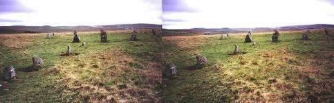
The stones forming the Southern end of the row can be seen leading towards the circle on the left of the picture.
Here is another view of the circle, from the North-east (original photo, 57 KB):
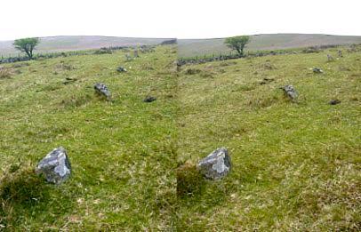
Staldon
Bronze Age Stone Row
Ordnance Survey Grid Ref: SX 632 625
O.S. Map (Streetmap)
Original Photo (Non-Stereo) (114 KB)
Extending for some 501 metres (1645 ft) over Stalldown Barrow hill, this enigmatic row comprises some of the tallest stones of any stone row on Dartmoor. It is orientated in a North-South direction, but like most rows on the moor, it does not follow the same orientation throughout its length, varying by several degrees and appearing disjointed in sections.
The photograph shows the Southern half of the row, looking Southwards.
An equally atmospheric stone row is situated further along the Erme valley 1.2 miles (1.9 km) to the North of Staldon row. The Stall Moor-Green Hill row is one of the most remote prehistoric sites in England and stretches over a remarkable 2.1 miles (3,398 metres or 11,150 ft) - the longest stone row known. At the Southern end of the row is a stone circle known variously as The Dancers (94 KB) or Kiss-In-The-Ring (SX 635 644). It is 16.5 metres (54 ft) in diameter and has 26 stones. The row leads northwards from the circle, undulating across the moorland and varying direction between NNE and NNW along the way. It crosses the River Erme and one of its tributaries and climbs gently up Green Hill, where it terminates close to a small round barrow (SX 636 678). There are numerous gaps in the row and many of the stones are small, but a visit to the site is well worth the long walk required to reach it.
 Stereoscopic
(3-D) Photographs
Stereoscopic
(3-D) Photographs
Copyright Martin J Powell 2003
Site hosted by TSOHost |
 Prehistoric
Sites in Wales
Prehistoric
Sites in Wales