![]()
|
|
Prehistoric Sites in
WALES
by Martin J. Powell
Page 1 of 5
Click on a thumbnail to see a full-size picture. The Ordnance Survey Map links (O.S. Map) point to the 1:25,000 scale map of the region (equivalent to the O. S. Pathfinder Series of printed maps), as displayed at Streetmap.co.uk.
The abbreviation 'Ast' indicates that the site is included in the archaeoastronomy study of monuments in South Wales.
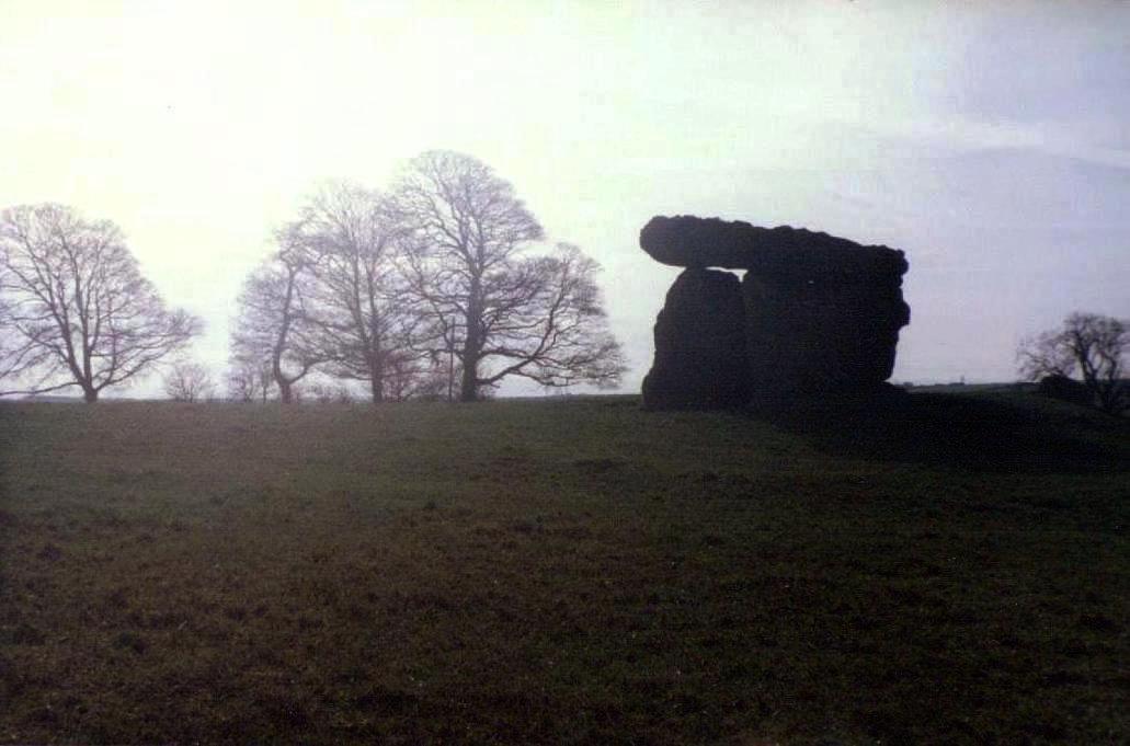
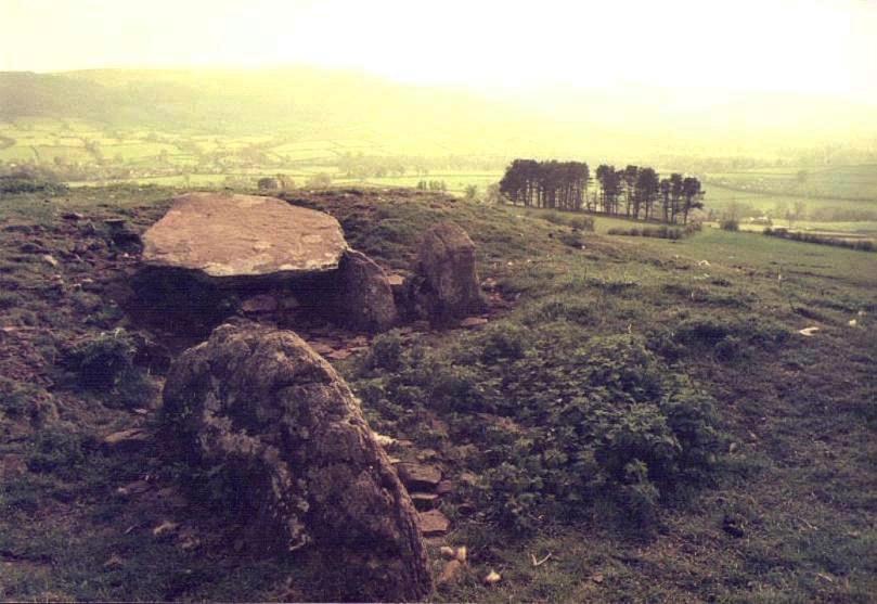
Maes-y-Felin a.k.a. St Lythans, Gw�l-y-Filiast Chambered Cairn County: Vale of Glamorgan (South Glamorgan) Ordnance Survey Grid Ref: ST 101 723 O.S. Map (Streetmap) Photo Size: 74 KB / Date: May 1987
Four mudstone slabs stand at the Eastern end of a much-ploughed down long mound, with three uprights forming a rectangular chamber some 6� ft (2 m) long by 5 ft (1.5 m) wide. Human remains and pottery were found in the chamber in 1875. The capstone is pitched upwards slightly towards the Eastern end (116 KB). There is a hole through the rear stone of the chamber, through which the spirits of the dead are said to have flown. An excavation of the site took place in 2011, which determined that the cairn measured 98 ft (30 m) long by 39 ft (12 m) wide. The much-robbed cairn comprised large limestone slabs along with boulders and small pebbles, all of which had been collected locally. Traces of a circular structure was evident around the chamber, suggesting that the monument might have been a two-phase construction, the chamber and circular cairn having been constructed first and the long cairn added later. Immediately around the chamber, large boulders and slabs were found to have been pitched upwards at an angle of about 45�, serving to provide support to the chamber uprights. Examination of the South-western corner of the cairn revealed a single layer of stones and slabs which had been laid on top of an apparent low-standing earthen mound. At the edges of the cairn was a poorly preserved revetment wall, which was found to be best preserved at the Western end. The monument would originally have featured a horned forecourt, much like that at the nearby Tinkinswood chamber (see Page 2). Most of this structure had however collapsed into the forecourt area, covering a layer of stones which had been used to close off the chamber at the end of the site's use. Finds from the recent excavation included fragments of Neolithic Grooved Ware pottery, fragments of a bone needle and a polished stone axe, several pieces of flint and some human bone and teeth. A local legend says that the field in which the tomb stands is cursed, and that nothing will grow there - apart from the grass, that is! [Ast] |
The Harold's Stones Stone Row County: Monmouthshire (Gwent) O.S. Grid Ref: SO 499 051 O.S. Map (Streetmap) Photo Size: 96 KB / Date: June 1989
A carving of the stones, dated 1689, can be seen on the base of a sundial (19 KB) in the nearby church. The heights of the stones are marked (in feet) and above them is a Latin inscription: MAJOR SAXIS "Greater in regard to the Stones" In 2002, a geophysical survey was carried out in the vicinity of the stones. It indicated the presence of a sub-rectangular ditched enclosure, of unknown date, measuring about 130 ft (40 m) in diameter. |
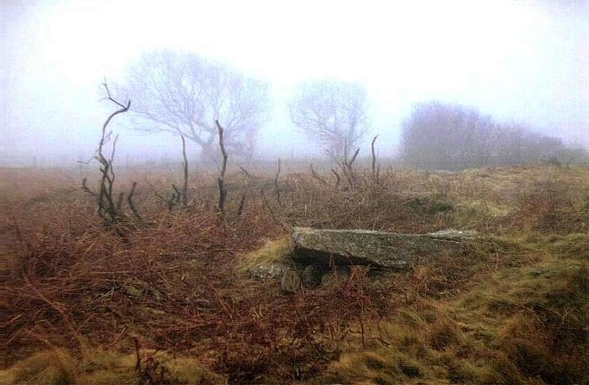
Ty Illtud Chambered Cairn County: Powys (Brecknockshire) O.S. Grid Ref: SO 098 264 O.S. Map (Streetmap) Photo Size: 71 KB / Date: May 1991
A "heape of stanes" once reported to have covered the chamber seems to have been removed in the 17th century. The name of the site means "House of Illtud", after the Franco-Celtic monk St Illtud (ca. 425-525 AD) who, it has been suggested, used the chamber as a hermit's refuge [Ast] |
Bryn Celli Ddu Chambered Cairn County: Anglesey (Ynys M�n) O.S. Grid Ref: SH 507 702 O.S. Map (Streetmap) Satellite Photo (Google Maps) Photo Size: 169 KB / Date: July 1987
Just behind the chamber - at the centre of the original mound - is a pit, in which wood and a human ear-bone were found. The pit was originally covered by a slab, and lying beside it was a stone which had been carved on both sides with spiral and zigzag patterns. The 'Pattern Stone' (as it became known) is on display at the National Museum of Wales in Cardiff; the stone visible at the monument today is a replica (180 KB), set into a concrete plinth (some of the carvings on the 'Pattern Stone' replica can be discerned in the photograph, indicated by the red arrow). In the original monument, the mound would have covered the chamber, the pit and the 'Pattern Stone' but today it has been deliberately truncated to allow the chamber and the carved stone to be easily viewed. The passage entrance is orientated towards the North-east and faced the rising Sun on midsummer's day. Indeed, it has been suggested that the entrance may once have included a 'roof box' to allow the Sun's rays to enter the passage, much like the one at at the Newgrange passage tomb in Ireland (which faces the midwinter sunrise). A short distance in front of the tomb's entrance is an enclosure, today demarked by five low-standing stones (visible in the upper picture). The stones occupy the positions of post-holes, which originally contained wooden posts, behind which was a pit containing the bones of a small ox. This structure may have been part of an earlier monument known as a henge, upon which the tomb itself was later built. The enclosure is set on a slightly different orientation to that of the tomb's passage. The design and structure of Bryn Celli Ddu has many similarities to the passage tombs located across the Irish Sea in Northern and Eastern Ireland. The tomb at Barclodiad y Gawres, some 17.8 kms (11 miles) to the West of Bryn Celli Ddu, is similar in form and also contains carved stones (see Page 5). |
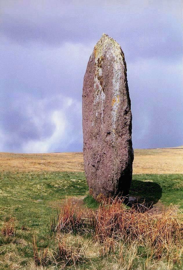
Maen Llia Standing Stone County: Powys (Brecknockshire) O.S. Grid Ref: SN 924 192 O.S. Map (Streetmap) Photo Size: 134 KB / Date: May 1987
In 2009 local megalith researcher Andrew Davies observed that, when the Sun drops below the mountain to the West of the stone around midsummer's eve, the shadow of the stone stretches downhill and touches the Afon Llia stream, some 230 ft (70 m) to the East of the stone. This might help explain an old legend which tells of the stone loving fresh water and walking to the River Nedd (Neath) for a drink whenever it hears the cock crow. Similar stories are associated with many prehistoric megalithic sites across the country. Maen Llia ('Llia's stone') marks the Northernmost point of an isosceles triangle, first identified by archaeologists in the 1980s, comprising the monolith, the Llech-Llia concentric ringwork (SN 923 189) and the Rhyd Uchaf cairn (SN 926 189), which presumably are all contemporary in age. Inside the triangle is a 'U-shaped' embanked platform (SN 924 190) measuring 26 ft (8 m) by 19 ft (6 m) which may have served as an observation platform of some kind. Davies also reported the discovery of a recumbent monolith partly projecting from a field-bank beside the road at SN 923 190, positioned precisely mid-way between Maen Llia and Llech-Llia. The centre-line (altitude) of the triangle, formed by the recumbent stone, the platform and the cairn, stretches across a distance of 980 ft (300 m), its apex pointing South-east towards the summit of Fan Llia mountain. The five monuments appear to have been part of a small ritual complex, with a pre-designed geometric relationship, occupying an area of about 3� hectares (8� acres). |
Nicholaston Chambered Cairn County: West Glamorgan O.S. Grid Ref: SS 507 888 O.S. Map (Streetmap) Photo Size: 69 KB / Date: March 1988
The original access was from the North-east, over a paved area and a sill-stone at the chamber entrance. Excavation in 1939 found no evidence of any entrance passage through the mound to the chamber [Ast] |
Heston Brake Chambered Cairn County: Monmouthshire (Gwent) O.S. Grid Ref: ST 505 886 O.S. Map (Streetmap) Photo Size: 104 KB / Date: November 1991
The chamber is positioned slightly offset from the passage, suggesting that the passage may have been a later addition to the chamber. Excavation in 1888 revealed skeletons in the chamber. In 2003 it was reported that several cupmarks are visible on the upper surface of the monument's Southern portal stone (the squat stone visible at the centre of the photograph) [Ast] |
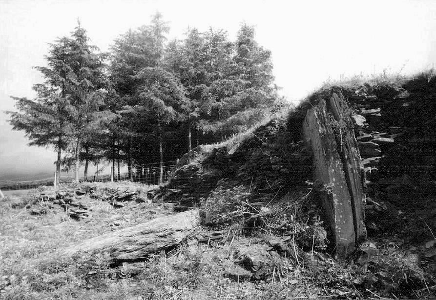
Penywyrlod (Talgarth) a.k.a. Pen y Wrlod Chambered Cairn County: Powys (Brecknockshire) O.S. Grid Ref: SO 151 315 O.S. Map (Streetmap) Photo Size: 135 KB / Date: June 1991
Radiocarbon dating of human bone from one of the chambers gave a date for the cairn's construction of around 3800 to 3600 BC, making it one of the oldest known cairns in Southern Britain. The chambers had been filled with rubble, and the forecourt blocked with stone, at the end of the cairn's use. A sheep's femur bone, punched through with three holes, was found in the entrance passage to one of the smaller chambers. It may have been a prehistoric flute or whistle - in which case, it is the oldest musical instrument yet found in the British Isles [Ast] |
Maen Madoc a.k.a. The Dervacus Stone Inscribed Standing Stone County: Powys (Brecknockshire) O.S. Grid Ref: SN 918 158 O.S. Map (Streetmap) Photo Size: 78 KB / Date: May 1987
On the side of the stone is a 5th-6th century Latin inscription (37 KB): DERVAC FILIVST IVST JACIT "Dervacus, son of Justus. He lies here." Excavation revealed no traces of a burial, although the acid soil of the region is likely to have destroyed any such traces. There is a possibility that the stone was originally a Bronze Age standing stone which, many centuries later, was re-used on two occasions: once as a Roman road marker and again as a burial marker in the so-called 'Dark Age' period. |
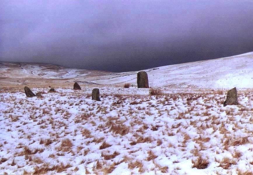
Cerrig Duon Stone Circle & Row County: Powys (Brecknockshire) O.S. Grid Ref: SN 851 206 O.S. Map (Streetmap) Photo Size: 97 KB / Date: March 1987
The noted archaeoastronomer Professor Alexander Thom considered that Maen Mawr, when seen from the centre of the circle, marked the rising position of the star Arcturus as it would have been around 1950 BC. About 0.6 miles (1 km) to the NNW of the circle, higher up on the slope of a mountain, is the Waen Lleuci (or Waen Llenai) monolith (22 KB, SN 854 215). It is 6 ft (1.9 m) tall and its long axis points towards the circle [Ast] |
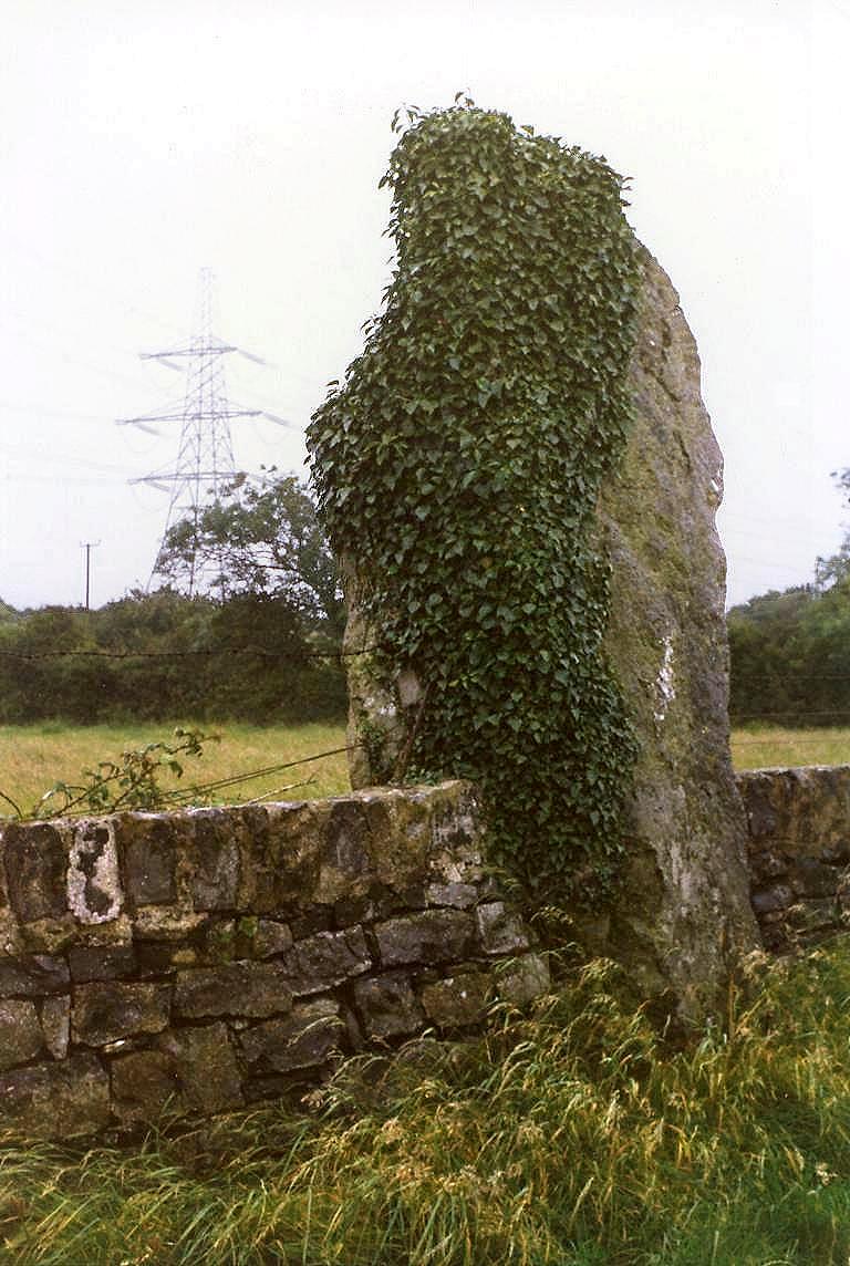
Maen Addwyn a.k.a. Maen Fabli Standing Stone County: Anglesey (Ynys M�n) O.S. Grid Ref: SH 461 834 O.S. Map (Streetmap) Photo Size: 135 KB / Date: July 1987
The stone is 11 ft 2 in (3.4 m) tall, 3 ft 11 in (1.2 m) wide and 2 ft 11 in (0.9 m) thick. It probably dates from the Bronze Age, but its original purpose is unknown. Maen Addwyn stands opposite the Ysgol Ty Mawr primary school - the smallest school on the island. |
 Archaeoastronomy
in South Wales
Archaeoastronomy
in South Wales
 Neolithic
Tombs in South Wales
Neolithic
Tombs in South Wales
Copyright Martin J Powell 2001 - 2017


 Prehistoric
Sites in Scotland
Prehistoric
Sites in Scotland