![]()
|
|
Prehistoric Sites in
ENGLAND
by Martin J. Powell
Page 3 of 5
Click on a thumbnail to see a full-size picture. The Ordnance Survey Map links (O.S. Map) point to the 1:25,000 scale map of the region (equivalent to the O. S. Pathfinder Series of printed maps), as displayed at Streetmap.co.uk.
Swastika Stone Rock Carving County: West Yorkshire Ordnance Survey Grid Ref: SE 095 470 O.S. Map (Streetmap) Photo Size: 166 KB / Date: July 1988
The stone has a double outline of a swastika, with ten cups fitting within the five curved arms. The design is similar to art of the Celtic Iron Age period, so the carving is likely to be later than the majority of other carvings on the moor. The figure in the foreground is a 20th century replica; the original carving can be seen a little further away, at the centre-left of the picture. |
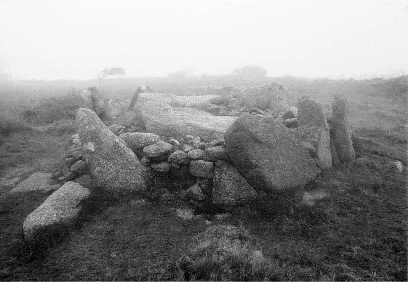
Bosiliack Chambered Tomb County: Cornwall O.S. Grid Ref: SW 431 342 O.S. Map (Streetmap) Photo Size: 68 KB / Date: June 1991
Part of an excavation trench can still be seen on the monument's eastern side. The chamber and passage face towards the South-east. The site has structural and design similarities to the Neolithic entrance-graves found on the Scilly Isles, some 28 miles (45 km) off the South-western tip of Cornwall. |
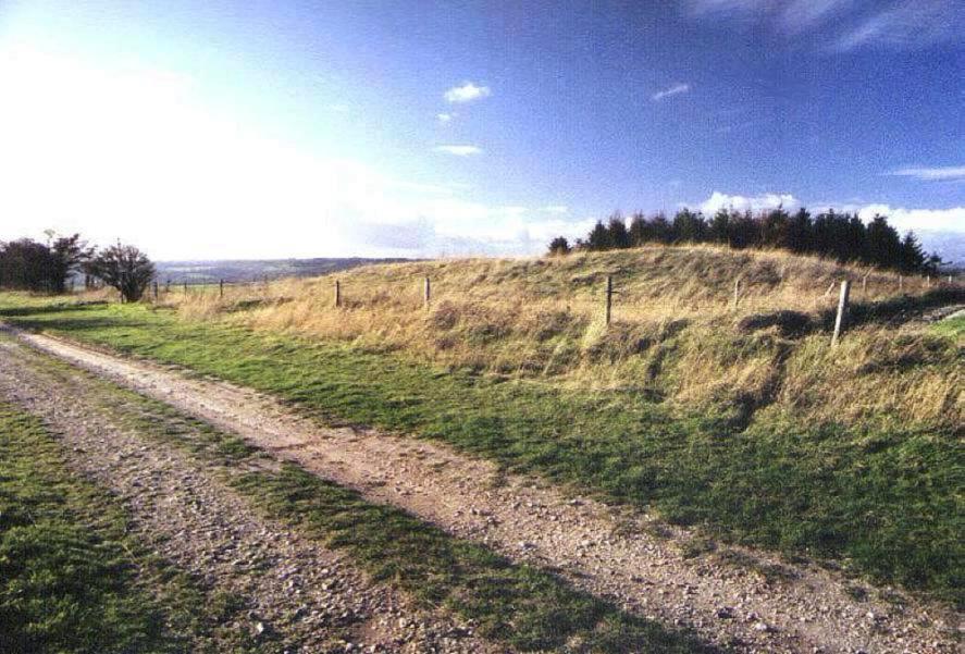
White Sheet Hill a.k.a. Ansty Long Barrow County: Wiltshire O.S. Grid Ref: ST 942 242 O.S. Map (Streetmap) Photo Size: 113 KB / Date: November 1996
Although this particular example is not quite a 'monster', archaeologist Aubrey Burl's description of the giant long barrows of Southern England aptly describes the appearance of these numerous Neolithic monuments. Situated beside a long hill-top trackway, the White Sheet Hill barrow is 134 ft (41 m) long, 75 ft (23 m) wide and stands 6� ft (2 m) high at its Eastern end. It is orientated ENE-WSW and has not been excavated. |
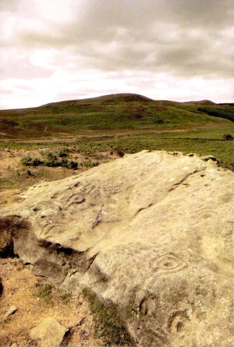
Garleigh Moor Rock Carvings County: Northumberland O.S. Grid Ref: NZ 055 990 O.S. Map (Streetmap) Photo Size: 129 KB / Date: July 1989
An extra cup and ring has apparently been added to one of the rocks by a vandal! This is just one of many examples of Bronze Age rock art which can be found carved on natural outcrops across the Northumbrian landscape. |
Weetwood Moor Cairn a.k.a. Weetwood Cairn Round Cairn County: Northumberland O.S. Grid Ref: NU 021 282 O.S. Map (Streetmap) Photo Size: 89 KB / Date: July 1989
The cairn's most outstanding feature is its kerbstone which has four concentric circles and three radial grooves carved into it. Although the carving is now clearly visible to passers-by, it would originally have faced inward; the inference being that the decoration was intended for the dead and not for the living. Such 'hidden decoration' has been found at numerous prehistoric sites in Britain and Ireland, where it has usually been assumed to have a ritual significance. Numerous cobbles were also found in the mound's structure which had been carved with cups and grooves, their carved sides mostly facing downward. Intriguingly, the Weetwood Cairn excavation found no signs of burial or cremation. |
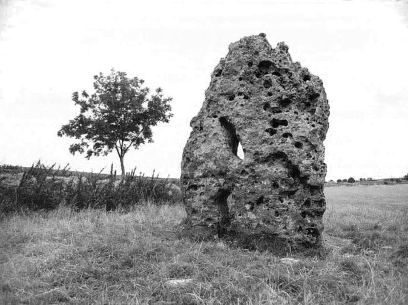
The Long Stone Standing Stone County: Gloucestershire O.S. Grid Ref: ST 884 999 O.S. Map (Streetmap) Photo Size: 78 KB / Date: September 1990
It is said that superstitious mothers once passed their babies through the stone holes in the hope of preventing whooping cough or rickets. A local legend says that the stone runs around the field whenever it hears the nearby church clock strike midnight. |
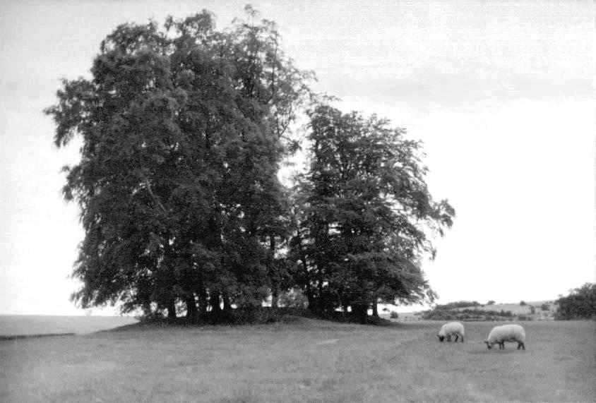
The Tinglestone Long Barrow County: Gloucestershire O.S. Grid Ref: ST 882 990 O.S. Map (Streetmap) Photo Size: 68 KB / Date: September 1990
Like at The Long Stone (above), The Tinglestone is also said to run around the field when it hears the local church clock strike midnight. |
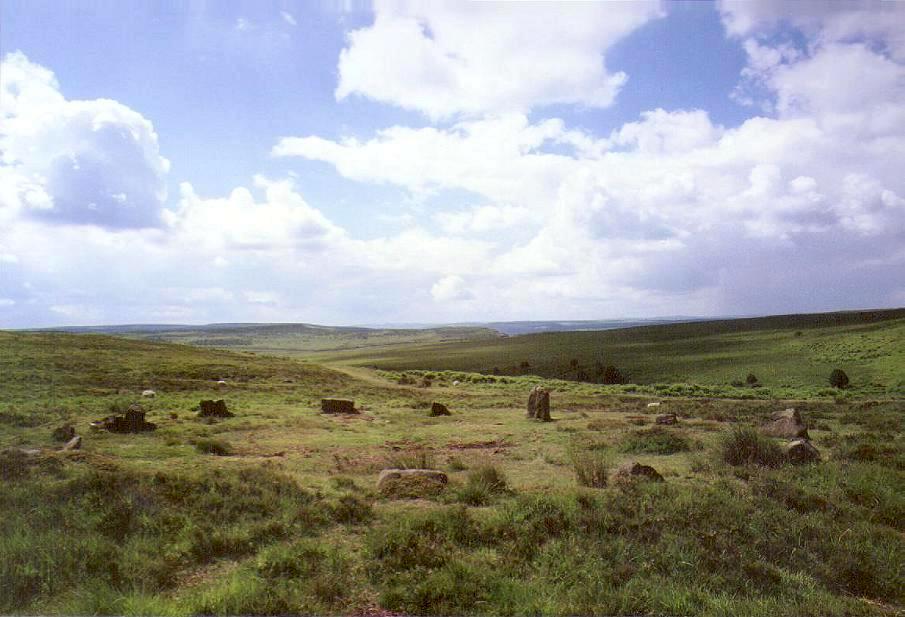
Barbrook I Stone Circle County: Derbyshire O.S. Grid Ref: SK 278 755 O.S. Map (Streetmap) Photo Size: 80 KB / Date: July 1988
The noted archaeo-astronomer Professor Alexander Thom labelled it a Type B Flattened Circle under his stone circle shape classification scheme, and suggested that a low-standing outlying stone to the WNW may have been aligned upon the rising of the star Spica in the Bronze Age around 2000 BC. There were no finds during a scant excavation in the 1930s. The more ruinous Barbrook II stone circle lies 900 ft (275 m) to the North (SK 277 758). |
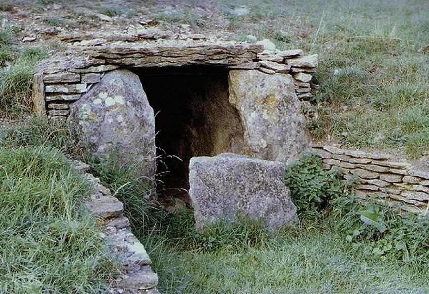
Lanhill Chambered Long Barrow County: Wiltshire O.S. Grid Ref: ST 877 747 O.S. Map (Streetmap) Photo Size: 147 KB / Date: September 1990
There were originally at least three chambers within the mound; the one pictured is the Southern chamber, which has been partly restored. The roof was originally corbelled and cairn material was found blocking the entrance passage. Eleven burials were found in this chamber. The barrow was excavated in 1909, at which time the false portal at the East was removed, and also in 1936, when one of the Northern chambers was discovered. Both Northern chambers are now destroyed. |
Swinside a.k.a. Sunkenkirk Stone Circle County: Cumbria O.S. Grid Ref: SD 171 881 O.S. Map (Streetmap) Satellite Photo (Google Maps) Photo Size: 83 KB / Date: July 1989
Two outlying portal stones form an 'entrance' 9 ft (2.7 m) wide at the South-east, which Alexander Thom believed was aligned on the rising of the midwinter sun over a nearby hill during the Bronze Age. Fragments of charcoal and burnt bone were the only findings during an exacavation in 1901. |
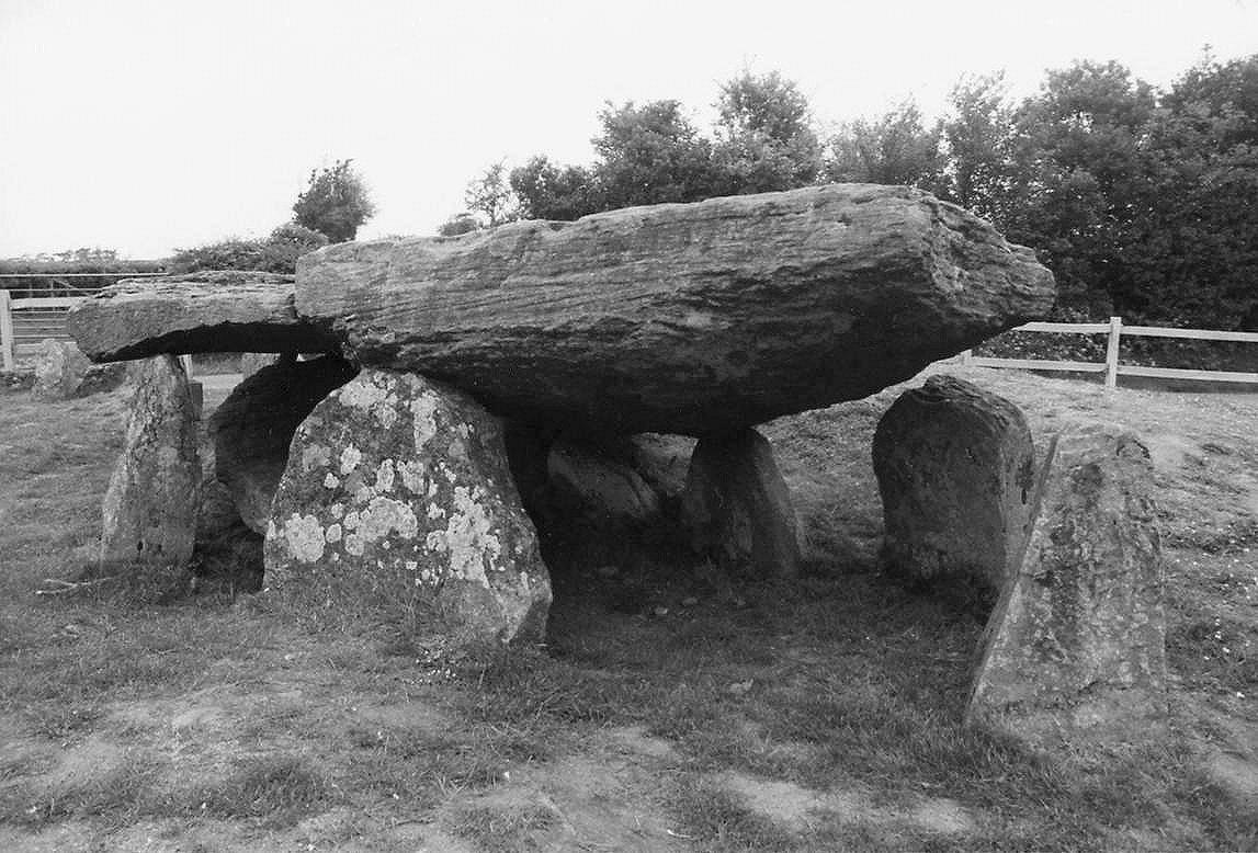
Arthur's Stone, Dorstone Chambered Cairn (Burial Chamber) County: Herefordshire O.S. Grid Ref: SO 319 431 O.S. Map (Streetmap) Photo Size: 146 KB / Date: May 1991
The capstone - of Old Red Sandstone - is polygonal ('kite-shaped') in plan and measures about 19 ft (5.8 m) long by 10 ft (3 m) wide. It is estimated to weigh around 25 tonnes. The layout of the nine tomb uprights neatly follows the outline of the covering capstone, which suggests that the capstone's shape was used as a template for the design of the main chamber. The entrance passage (167 KB), some 20 ft (6 m) long by 4 ft (1.3 m) wide, approaches the chamber from the West then bends Southwards through a severe 80� angle before reaching the chamber, which is partly blocked by a portal stone. The size and shape of the original cairn has been the subject of much debate over the years. The present appearance of the surrounding low-lying mound would suggest an oval cairn about 85 ft (26 m) long by 55 ft (17 m) wide, orientated North-South. However, an archaeological evaluation of the site undertaken in 2006 strongly suggests that the cairn was originally trapezoidal in plan, the cairn having extended Northward from the chamber across Arthur's Stone Lane and into the adjacent field. About 13 ft (4 m) South of the chamber is an upright sandstone slab, known as the Quoit Stone, which reportedly has twelve large but shallow cup-marks (man-made circular depressions) on its Northern side. It has recently been suggested that this slab may have formed part of a false portal (blind entrance) occupying the Southern end of the cairn - in which case, it seems the cupmarks were intentionally hidden from view. In having a trapezoidal cairn and a false portal, the design of this cairn would therefore echo those of the Black Mountains group of terminally-chambered long cairns situated across the Welsh border to the South-west of the site (see for example Penywyrlod (Talgarth) and Ffostill North in the Prehistoric Sites in Wales gallery). The tomb's name derives from a local legend which says that it is the burial place of King Arthur or that of a king or a giant of whom he killed. |
 Neolithic
Tombs in South Wales
Neolithic
Tombs in South Wales
Copyright Martin J Powell 2001 - 2017


 Prehistoric
Sites in Wales
Prehistoric
Sites in Wales
 South
Dartmoor in 3D Stereo
South
Dartmoor in 3D Stereo A
Round Barrow in Gwent
A
Round Barrow in Gwent